 ar
ar bg
bg hr
hr cs
cs da
da nl
nl fi
fi fr
fr de
de el
el hi
hi it
it ko
ko no
no pl
pl pt
pt ro
ro ru
ru es
es sv
sv tl
tl iw
iw id
id lv
lv lt
lt sr
sr sk
sk sl
sl uk
uk vi
vi et
et hu
hu th
th tr
tr fa
fa ms
ms hy
hy ka
ka ur
ur bn
bn mn
mn ta
ta kk
kk uz
uz ku
ku
Tilt Sensor
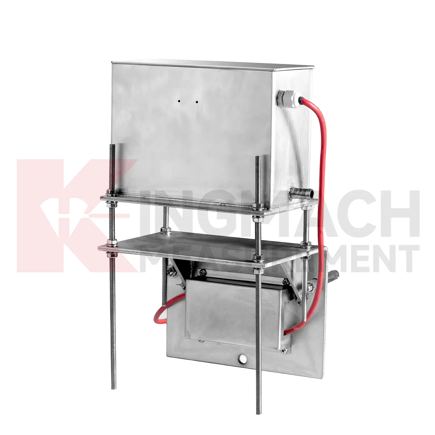
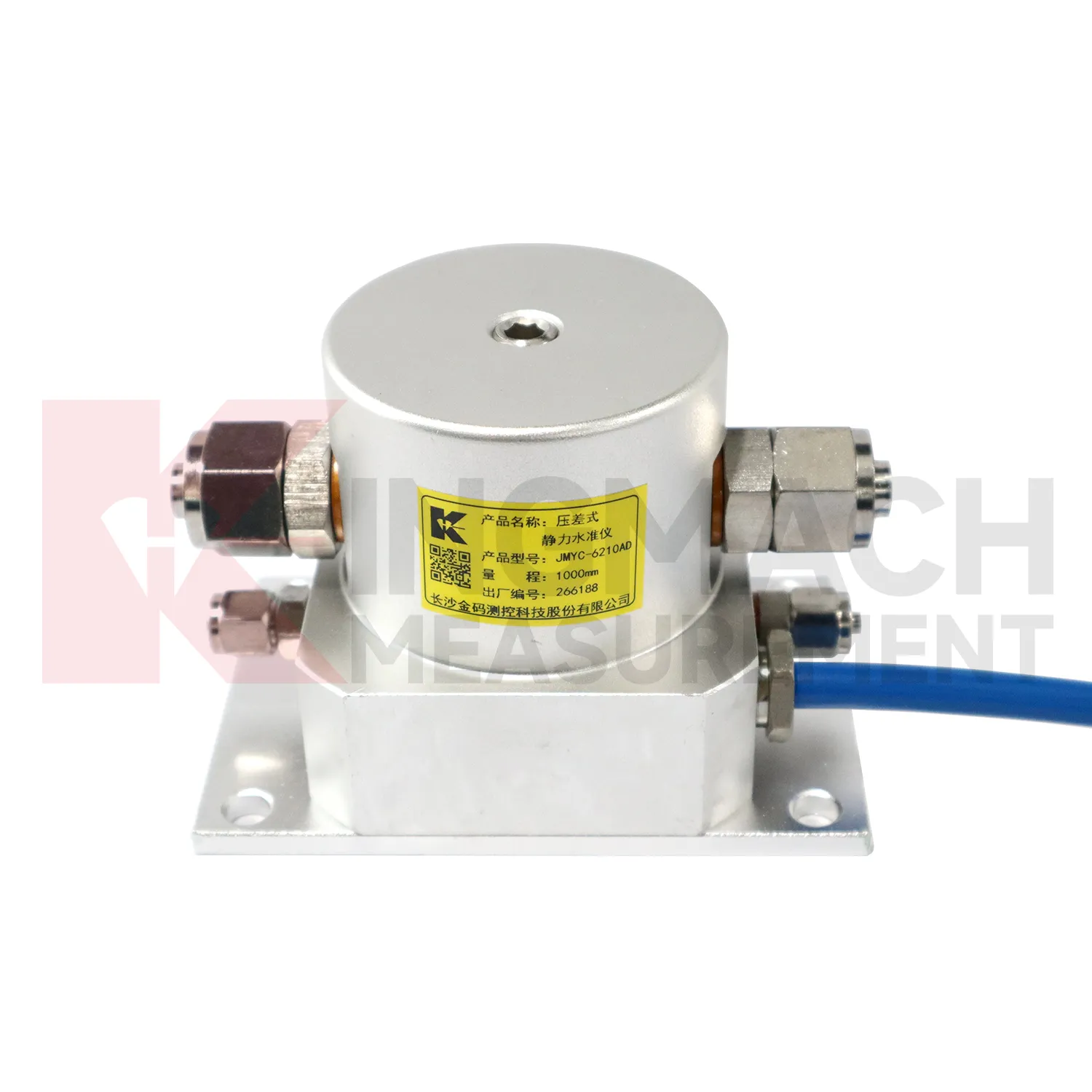
The JMYC-62XXAD wide-range differential pressure hydrostatic level sensor extends Kingmach Tilt Sensor into projects where settlement may be too large for micro range instruments. It works as a reference-point hydrostatic system for uneven pavement settlement, nonlinear cross-section settlement, soft foundation treatment, land reclamation foundations, dam settlement, bridge deflection, slope stability, and building settlement. Published specifications include 500 mm, 1000 mm, 2000 mm, and 4000 mm ranges, 0.1 mm resolution, 0.2%FS accuracy, RS485 output, DC 9V to 24V supply, power consumption below 0.5W, and an operating temperature from -30 degrees Celsius to +80 degrees Celsius. The instrument is especially relevant when a profile may keep moving during filling, preloading, or staged construction. Planning should define the fixed reference point first, then divide the section into measuring locations that can reveal uneven deformation. Cable protection, cabinet access, sensor elevation, and construction vehicle paths need early coordination. When the data is reviewed later, the wide range helps distinguish gradual consolidation from sudden local movement across a road, reclamation area, or embankment section.
Application of Tilt Sensor
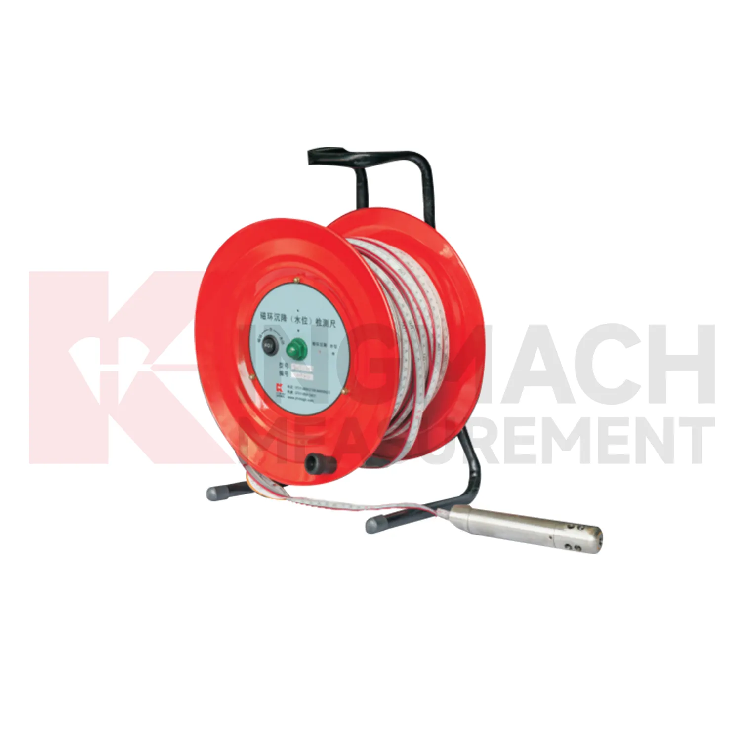
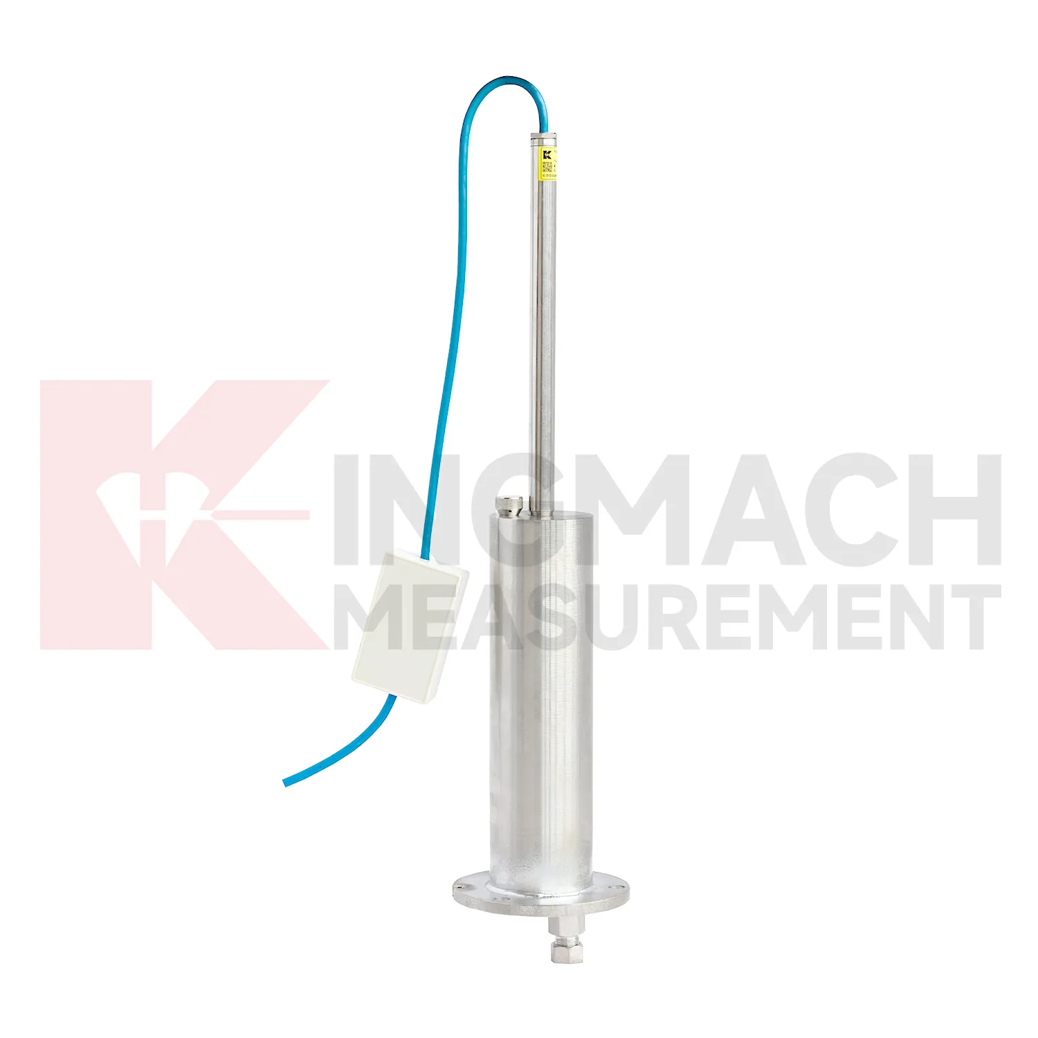
Layered soil, slope, and embankment projects often need Tilt Sensor that can separate underground compression from groundwater variation. Kingmach JMCJ-1003/1005 magnetic ring settlement water level gauge serves that role through a probe, reel, measuring tape, magnetic rings, and water-level detection. Magnetic rings are placed at selected depths, and the probe gives audible and visual indication when it reaches a ring. Water level is detected by conductivity when the probe contacts water. Published options include 30 m, 50 m, and 100 m depths, plus or minus 1 mm accuracy, a 9V battery, and a probe about 17 cm long with 3 cm diameter. This manual instrument is useful when the engineering question is not just total surface settlement, but which soil layer is compressing. Field crews can compare ring depth, groundwater depth, rainfall, fill placement, cracks, retaining wall movement, and excavation activity. The resulting profile helps identify whether deformation is shallow, deep, water-related, or linked to a particular construction stage.
The future of Tilt Sensor
Future Tilt Sensor will use smarter edge checking before data reaches the main platform. A sudden settlement jump may come from real ground movement, but it may also come from a disturbed tube, loose cable, air pocket, dewatering activity, cabinet work, or reference point change. Acquisition units can compare settlement rate, water level, rainfall, temperature, and nearby channels before marking a value as reliable. Kingmach products with RS485 output and automated acquisition compatibility already provide a basis for this kind of review. For remote railway subgrades, dams, tunnels, and slopes, early filtering can reduce unnecessary field visits while still flagging readings that need inspection. The aim is not to hide abnormal movement, but to separate data-chain faults from structural behavior faster. The practical goal is to keep settlement data understandable after the original installation crew has left, so owners can compare old and new readings without reconstructing the field history from memory. The same record should remain readable for designers, contractors, owners, and maintenance teams, because settlement monitoring often continues long after the first construction report is finished.
Care & Maintenance of Tilt Sensor
Hydrostatic Tilt Sensor need regular checks of the liquid path. For systems using JMDL-62XXADT, JMQJ-62XXADT, or JMYC-62XXAD, inspect water pipes, connectors, sensor elevation, reference point, cabinet wiring, and tube protection. Kinks, leakage, air pockets, freezing risk, or construction damage can change the apparent settlement curve. Check whether readings change after pipe work, cabinet maintenance, or nearby excavation. For outdoor systems, protect tubes from vehicle traffic, sharp edges, workers, and animal damage. When a reading shifts suddenly, confirm the reference sensor and water path before treating the value as structural movement. Hydrostatic systems can be very useful, but they depend on a clean, continuous, well-documented connection between points. The record should include who inspected the point, what changed on site, and whether nearby instruments showed the same trend, so the maintenance team can separate sensor trouble from real settlement. The record should include who inspected the point, what changed on site, and whether nearby instruments showed the same trend, so the maintenance team can separate sensor trouble from real settlement.
Kingmach Tilt Sensor
Layered ground behavior is another reason to use Tilt Sensor. Kingmach JMCJ-1003/1005 magnetic ring settlement water level gauge measures underground layer settlement and groundwater level in foundations, subgrades, foundation pits, embankments, and other underground structures. Magnetic rings are installed in boreholes, and the probe emits audible and visual alerts when it senses a ring. Water level is detected through conductivity when the probe contacts water. The listed accuracy is plus or minus 1 mm, with 30 m, 50 m, and 100 m depth options. This method gives engineers a way to separate shallow settlement from deeper layer movement while also seeing water level variation. It is especially useful when soil behavior and groundwater are tied together. If the curve changes suddenly, field teams should check reference stability, cable or tube condition, recent work, and weather before treating the value as structural movement. If the curve changes suddenly, field teams should check reference stability, cable or tube condition, recent work, and weather before treating the value as structural movement.
FAQ
Q: What is JMCJ-1003/1005 used for?
A: It is used to measure layered underground settlement and groundwater level in foundations, subgrades, foundation pits, embankments, and underground structures.
Q: How does magnetic ring settlement reading work?
A: Magnetic rings are placed underground; when the probe senses a ring, audible and visual alerts help the operator read depth from the steel tape at the borehole.
Q: How is water level detected?
A: The water level component works by water conductivity and alerts when the probe contacts water.
Q: What accuracy is listed?
A: The listed measurement accuracy is plus or minus 1 mm.
Q: What field records are needed?
A: Keep borehole number, magnetic ring depth, previous reading, current reading, groundwater level, and operator notes together.
Reviews
Matthew Garcia
Instrumentation cables are durable and perform well even in harsh environments. Will definitely order again.
Christopher Martinez
Very satisfied with the readouts & data loggers. User-friendly interface and supports multiple sensor inputs.
Latest Inquiries
To protect the privacy of our buyers, only public service email domains like Gmail, Yahoo, and MSN will be displayed. Additionally, only a limited portion of the inquiry content will be shown.
Evelyn***@gmail.comSouth Africa
Hi, we are a contractor working on tunnel construction and need settlement sensors and displacement ...
Mia***@gmail.comNetherlands
Dear team, we are interested in your readouts & data loggers compatible with multiple sensors. Do yo...